When you mention you are planning a visit to New Zealand the next question is usually whether you are headed to the North or South Island. There are actually around 600 New Zealand islands, many of them incredibly beautiful and unique, so let me add a few more options to your list to think about.

To make your itinerary planning a little easier we’ll go through them in order, north to south and show them here on the map so you can see them in context of where you are already going and where you might want to add in an island detour.
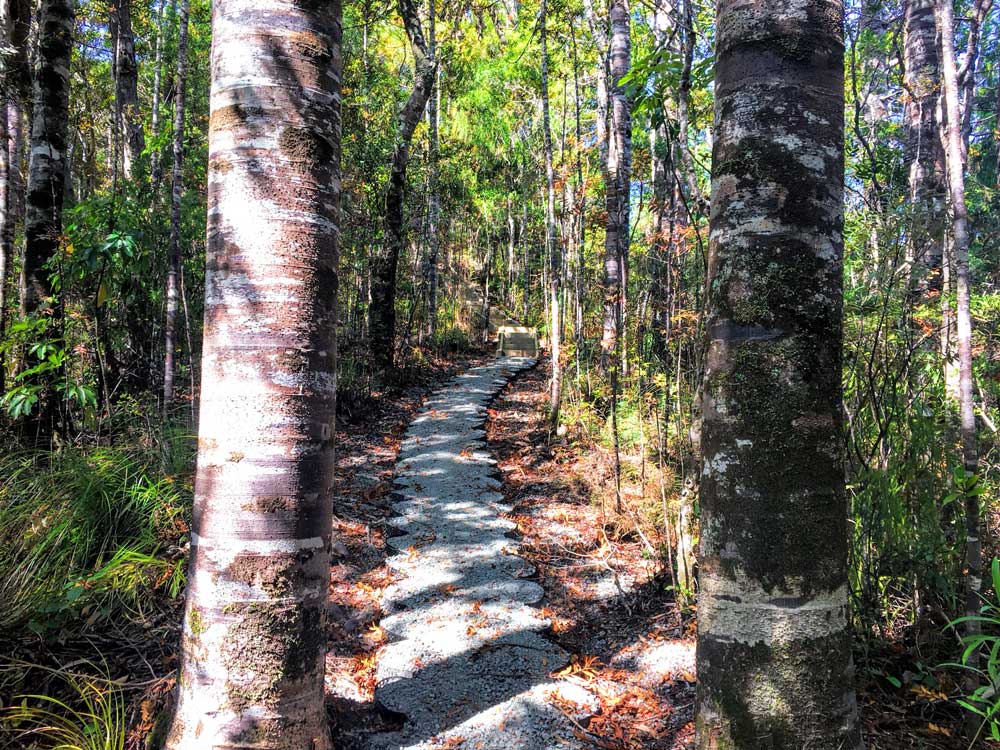
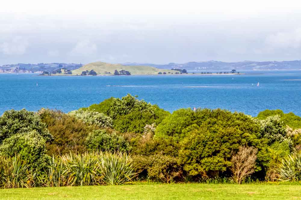
Urupukapuka Island
Urupukapuka is the largest island in the Bay of Islands, which is located in the Northland region of New Zealand, known as the Winterless North due to its mild climate.

Urupukapuka Island makes the perfect day trip from Paihia or Russell. In the summer there are regular ferries ($50 return) and year-round you can book a water taxi—both take about 40 minutes to reach the island and you might see dolphins on the way.
It’s one of the most beautiful places in the country with lush green hills, sandy beaches, and dramatic cliffs. The calm bays are ideal for swimming, snorkelling, and kayaking (you can rent kayaks on the island in summer).
As the island is pest-free, there are many native birds including pukeko, North Island saddlebacks, tui, and fantails, and you’ll hear their song as you walk through the forest.
You could enjoy a great day out in the summer by lazing on the beaches and visiting the cafe at Otehei Bay, but it’s well worth hiking the various trails around the island. It took us 4.5 hours (including an hour for breaks) to walk 11.5km (7 miles)to almost all the trails and beaches—most of which we had to ourselves in the autumn.
You can also camp at a few of the beaches which would be an excellent way to have more time on this stunning island.
Erin at the Never Ending Journey blog has a comprehensive guide to visiting Urupukapuka Island, if you’re planning on heading over check that out for more tips.
Aotea – Great Barrier Island
For those who love New Zealand’s multi-day hikes, you may already have Great Barrier Island on your radar. Drew sailed out there years ago but we’ve not hiked it yet so I appreciated receiving this teaser from Exploring Auckland.
Aotea – Great Barrier Island is one of many stunning islands found in regional Auckland. Off the well-worn tourist trail, this island is a taste of what New Zealand felt like decades ago.
Isolated but surprisingly accessible from downtown Auckland, it feels a little like an undiscovered gem right on urban New Zealand’s doorstep.
Home to the only multi-day hike in Auckland, the Aotea Track spans approximately 25km and takes three days to complete (though it can be done in less). Along the way, you’ll enjoy incredible views, birdlife and natural hot springs to bathe in. This is New Zealand as it is meant to be enjoyed!
Though the Aotea Track attracts many to the island, Great Barrier Island offers much more than just hiking.
This small community is tight-knit but welcoming. Running off-grid, some resources are scarce (you won’t see any street lamps, for example), but offers of hospitality are off the charts.
Not only does the island’s remote nature benefit visitors who enjoy native flora and fauna, but the night sky looks pretty special there too. As one of only eleven ‘dark sky sanctuaries’ in the world (as of April 2020), it is the perfect place for stargazing and astrophotography.
If you’re looking for a taste of old-town New Zealand, whilst enjoying the most incredible beaches, scenery and hiking, Aotea Great Barrier Island really should be next on your list!
Tiritiri Matangi
This is one of our favourite island day trips from Auckland and you can take the ferry from either downtown Auckland or the shorter distance crossing from the Whangaparoa Penninsula. Tours usually run only on weekends with a single sailing each day so it is worth booking in advance for this one.
Check prices, days and tour times
New Zealand is known around the world for its flightless bird, the Kiwi, but did you know it has a second flightless bird that is just as unique to New Zealand and also endangered called the Takahe? Tiritiri Matangi is one of the best places to see it, you could pretty much guarantee someone a sighting here. There is Kiwi here too but given their nocturnal habits they are much more difficult to spot.
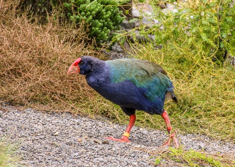
The island was once cleared for pasture land but in 1984 a reforestation project was started, a program to eradicate pests followed and since then it has been successfully repopulated with many species including the Takahe, the Tuatara, the little spotted kiwi, the Saddleback and one of New Zealand’s adorable parrots, the Kaka, among many others.
There are several walks on the island. The shortest is around 1 km and will take you only around 20 minutes to get up to the visitors centre. For the longer option around the island taking in both the Wattle and Kawerau track allow 4 hours at a slow stroll giving time to stop regularly and spot the wildlife.
There are no shops on the island so you’ll want to pack drinks, lunch and anything else you will need for the day. We recommend sunscreen and something warm to wear on the boat on the way back even on a summers day.
Waiheke Island
Waiheke Island is the second-largest and the most populated of the islands in the Hauraki Gulf. While it offers the stunning beaches, serenity and lush coastal headlands you’d expect, it’s also known for its olive groves and wineries.
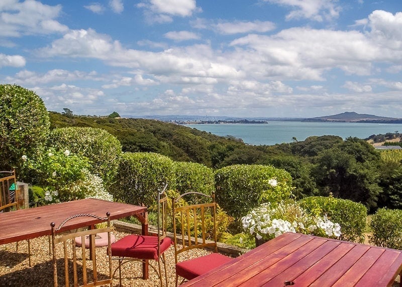
This is the Mud Brick Winery and is one of the longest established, most popular and in my view, best positioned on the island. From here you can soak up the sun, have a glass or two of chilled chardonnay and look out at the distant views of the city and other nearby islands.
Waiheke also offers a number of native bush tracks, and scenic coastal hikes with similarly stunning views. If you don’t plan to use other transport the Northern Walk starts near the ferry Matiatia Wharf and then follow the headland track through to Cable Bay, Owhanake Bay, and Oneroa Village. At the end of the day, or weekend if you are staying over continue the loop back to Matiatia.
The walk is around 8.5 km and you should allow 2.5 hours walking if you just do the loop but you’ll want to detour down to the beaches and perhaps into a couple of the vineyards as you go. Mud Brick, Jurassic Ridge and Cable Bay Wineries are each only a short detour from the loop.
The ferry makes the 40-minute trip from the Auckland Ferry Terminal up to 24 times a day at a cost of around $42 for the return ticket. There are also options to join a winery tour or to get an inclusive ticket with the hop on hop off bus that meets the ferry.
You’ll find more information on Waiheke Island and many other attractions in our detailed guide to Auckland.
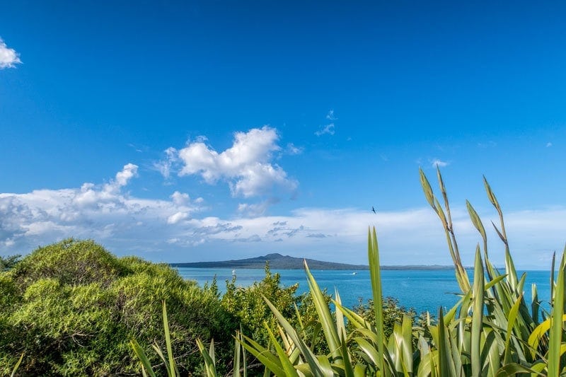
Rangitoto Island
Dominant on the Auckland horizon and instantly recognisable is Rangitoto Island. A dormant volcanic cone from 600 years ago, it is almost perfectly symmetrical meaning it looks exactly the same whether you look at it from the city beaches, the North Shore or out on the water. This image below is from the Savage Memorial gardens in Mission Bay.
Despite looking green from a distance the island has an arid and rocky terrain often refered to as resembling a moonscape. There are walking paths around the island and up to the summit which historically was used as a lookout point by Maori living on nearby Mototapu Island.
There’s a couple of ferry sailing each day from downtown Auckland and Devonport but you’ll want to plan ahead to ensure you have the right amount of time for your visit. It takes about 25 minutes to make the crossing and costs $36 for the return ticket.
There are a few different walking tracks on the island but they can be easily combined to see the best attractions including the coastal route, a series of small bays including McKenzie Bay, stunning views of the city from the summit, a peak into the volcanic crater and the lava caves.
It’s around a 12 km walk and you’ll need to allow about 4 hours, it’s easy walking with some elevation to make it up to the summit. You’ll be walking on a volcanic rock road initially then narrower but still well-formed tracks. The lava rock reflects the heat and suns burning rays so do take plenty of water and sunscreen.
Mototapu
Rangitoto is joined to neighbouring Mototapu Island by a causeway so you can simply walk across but despite the proximity the two are strikingly different. Caroline from CK Travels tells us more.
Motutapu is one of the less visited islands in Auckland’s Hauraki Gulf, and one of the oldest at 178 million years old.
Over the centuries, this lush green and grassy island has played home to Maori settlements, Victorian picnic parties and a World War II military base (the remnants of military barracks can still be seen today). Now the island is a pest free Department of Conservation ‘Recreation Reserve’ and is perfect for hikers and visitors who want to spot rare and native New Zealand birds.

The island has a series of easy and scenic walking tracks of varying length (you will find no public transportation here). One of the shorter walking tracks will take you to a beautiful and unspoilt beach called Sandy Bay which is perfect for a picnic and swim. If you have more time, head to Billy Goat Point, the northernmost part of the island. If you fancy visiting two islands during your trip, you can also access neighbouring Rangitoto island by a short causeway that connects the two.
Motutapu Island is a perfect day trip from Auckland and is easy to reach by a passenger ferry operated by Fullers. The journey takes 35 minutes and the return fare is $39, however, the ferry service is very limited and runs once every 2 weeks on a Sunday (Rangitoto has a more frequent daily schedule). Take good walking shoes with you, plus food and drink as there are no shops on the island.
Browns / Motukorea Island
This is a small island off Musick Point in St Heliers, one of Auckland’s city beaches. It’s a little different to visit than many others in the Hauraki Gulf because you can’t take a ferry out here but you can get here either by private boat or my preference, a sea kayaking tour. Both Auckland Sea Kayaks and Fergs Kayaks run tours.
Motukorea was once a volcano, like many of the other islands in the area. It is now extinct and one of the best-preserved examples. If you are interested in Auckland’s volcanic field I’d recommend the visit and a climb to the top of the scoria cone to look down into the deep crater, you can also see the tuff ring and upper lava flows clearly.
Rotorua Island
This one hasonly been open to the public since 2011 but now that it is it’s well worth checking it out. Jordan from Inspired by Maps headed out there and shares what makes it worth adding to your itinerary.
Only a quick one-hour ferry trip away from the Auckland CBD, Rotoroa Island, is one of the most fascinating islands in New Zealand, even if it is rather small. While Auckland’s Hauraki Gulf is home to many islands, Rotoroa Island may be its best-kept secret.
Now open to the general public for the first time in a century, this beautiful place has unique fauna, an exciting history, glorious views, white sand beaches, and attractive accommodation options.

Positioned at the eastern end of (more famous) Waiheke Island, this 82 hectares island has a long history, which is well covered in a small museum on the island. Spoiler alert: it was a rehabilitation facility for the past century where alcohol and drug addicts from the city where shipped off to. Today, however, thanks to a generous benefactor, the island is a sanctuary of a different sort.
A tranquil, unpretentious place of regenerating bush and a place for many of New Zealand’s iconic bird species to recover in a predator-free space. Yes, Kiwi, Weka, Tieke (saddlebacks), Popokotea (whiteheads) Oi (Grey-faced petrels), and even the rare Takahe can now be spotted here.
There are plenty of walks you can complete on a day trip to Rotoroa Island, exploring quiet beaches, old forests, new bush, and wetlands. Or you can just pack a picnic, go for a swim and let the wildlife come to you. Rotoroa Island is truly one of New Zealand’s best islands, and you should try to visit as soon as possible!
Whenuakura Island
The Coromandel can be visited as a day trip from Auckland but is much better suited to a weekend escape. Alex from Discover Aotearoa fills us in on why this little island is one for your must-see list.
Off the coast of Whangamata in the Coromandel lies a beautiful, hidden gem: Whenuakura Island. The island, also known as Donut Island, is really an ancient collapsed volcano. The English name came about due to its formation (round with a hole in the middle) but locals prefer to call it by its original Māori name, Whenuakura.

From the outside, Whenuakura Island looks like any other little island you can find in New Zealand. Overgrown with bush and trees, you wouldn’t think there’s an entrance to one the most magical places I’ve come across in Aotearoa New Zealand.
You’ll need to attend a kayak tour to enter the island as it can be quite dangerous if the swell is high and the tide too low. Kayaking into the island through a cave, it feels like one of these islands you see in pirate movies, where the treasure is buried.
The water is a bright turquoise, there’s a little sandy bay and all around you high walls covered in bush. For a long time, you’ll be sitting in your kayak and just stare in awe.
The island is a wildlife sanctuary and deemed ‘tapu’ (sacred) so it’s not allowed to set foot on the island itself. But nothing stopping you from plunging into the emerald water.
Whangamata lies at the bottom of Coromandel’s East coast. You can get there by either driving the loop around the peninsula or cut right through it if you don’t have much time. Next to Hot Water Beach and Cathedral Cove, Whenuakura is often forgotten but it’s well worth the visit!
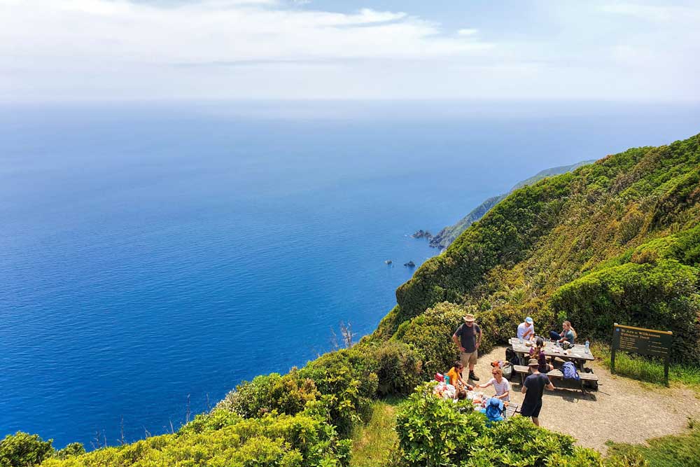
Kapiti Island
I wanted to visit Kapiti Island while we were in Wellington but we didn’t get out there so Jub from Chur New Zealand has been good enough to share his experience. How stunning is that!
Kapiti Island is 4km off the Kapiti Coast which is less than an hour drive north of Wellington. If you to visit, you need to book a trip with Kapiti Island Eco Experience or Kapiti Island Nature. There’s a limit on the number of daily visitors to the island, and these two companies hold the permits.
While you can stay overnight on the island, a day trip is enough for a good look around. Kapiti Island is steeped in history, with various changes in ownership, and was once a base for whalers.
Since 1987 when the Department of Conservation started to look after Kapiti Island it has become a world-class bird sanctuary. They managed to eradicate all the pests from the island, which has allowed the native trees and wildlife to thrive. They’ve also been able to bring endangered species to the island. And yes, kiwi (the birds) are on the island (you’ll need to stay overnight for a chance to see them).
Once you’re on the island, you get a short briefing about etiquette on the island before you’re left to explore the tracks on your own. There are plenty of tracks, and regardless of your fitness level, you will get a chance to see some native birds. There are never any guarantees with wildlife, but I’d be very surprised if you didn’t have any wow moments.
If you’re up for it, I recommend walking to the island’s summit which is 500 metres above sea level. On the way, you’ll hear a chorus of bird sounds, and spot a bunch too. If you’re not careful a couple of cheeky birds will steal your lunch from your hands.
If you’re as excited about this one as we are you can check out Jubs full article on his Kapiti Island day trip experience.
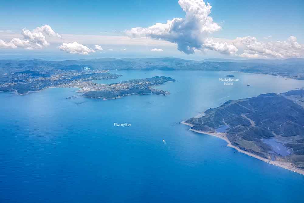
Matiu / Somes Island
In the middle of the Wellington Harbour is Matiu/Somes Island. The island has an interesting and diverse history, the site of 2 Maori Pa in pre-European history, as a quarantine station for Spanish Flu after the Great War and subsequently for animal quarantine. Now it is a rugged and beautiful wildlife sanctuary for native New Zealand birds and reptiles.
You have a chance of spotting the worlds smallest penguin around the shore line here and the Tuatara, a reptile whose origins date back to the Triassic period 240 million years ago.
Ferries stop out here a couple of times a day as they run between Wellington City and Eastbourne. It takes 25 minutes to get out here and a return ticket will cost $25.
We’ve got more details for you in our detailed visitors guide to Wellington city.
Stewart Island
We’ve yet to make it as far south as Stewart Island. Of course, it is on the list, especially after Josie shared her thoughts on why it’s so essential to make it right to the bottom of New Zealand.
Generally known as New Zealand’s third island, Stewart Island is located right at the south end of the South Island. Getting there can be an adventure in itself on the 30-minute ferry ride over from Bluff.
** Just a note: The Bluff oyster season is open March to August if you are a fan and time it right! **

Stewart Island only has one main town, Oban, which is where you will arrive and spend most of your time. There is accommodation available ranging from backpackers hostels to luxury B&Bs. You will not find chain hotels here.
With only a population of around 400 people, Stewart Island is a relaxed, nature destination. You won’t find any crowds here and your visit will run on the relaxed island time. One of the best things to do is simply take some of the nature walks around Oban. There is plenty of wildlife to be seen, and Stewart Island is the best place in New Zealand to see the Kiwi in the wild, with over 20,000 of this elusive, nocturnal bird calling the island home.
If you want a more challenging hike, Stewart Island is also home to one of New Zealand’s Great Walks, the three-day Rakiura Track.
Once you return from your walks, you can relax on pristine beaches or enjoy the fresh local seafood at the only pub in town. If you are here on the weekend, join in with the raucous Saturday Night pub quiz with both locals and visitors alike.
If that’s not enough to make a fabulous relaxing getaway, you may just find you are also lucky enough to top off your stay by spotting the Aurora Australis. Being furthest south, this is the best places in New Zealand to see the spectacular southern lights.
If you plan to head this far south be sure to read more of Josie’s tips for visiting Stewart Island.
Of the 600 New Zealand islands this only just begins to scratch the surface but is an overview of some of the most popular choices that offer a unique and beautiful glimpse into New Zealands diverse and beautiful geography and nature.
If you found this useful please consider saving it to Pinterest. It helps us, and it helps other travellers to find the information they need.

The post Which New Zealand islands will you visit? Going beyond North or South. appeared first on 2 Aussie Travellers.
from 2 Aussie Travellers
No comments:
Post a Comment